The
Age of Ice
A
preview from The Edgewalker's Guide to 20 great beaches on Lake Ontario
to be published in 2002
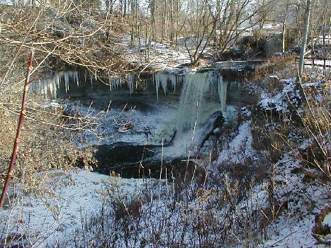
Wolcott Falls, a public waterfall in Wayne County
Lake
Ontario's shoreline lies in a land shaped by ice and water. Ours is a
topography of kames, moraines, kettles, drumlins and prehistoric beaches. The
vast ice sheet that covered this area 10,000 years ago continues to impact
people's lives today. When the farmer discs and plants his field with the rocky
knoll and the sandy patch or when the gardener struggles with cloddy sticky
clay, they are reliving that glacial history.
The
last ice age occurred between two and three million years ago and consisted of
at least four major ice advances. The last of these was about 18,000 years ago
and at that time ice completely covered present day Lake Ontario. It's believed
that when it finally began to melt, it retreated considerably faster than it advanced.
It's also known that the retreat was not a simple one way affair. There were
milder spells and colder times when the ice paused and even re- advanced.
No
one really knows for certain just what caused that first unusually cold snowy
year when spring never came. Perhaps massive volcanic eruptions like that of
1815, "the year without summer" when Tamboro erupted in the East
Indies and blew about 200 cubic kilometers of earth into the air, sent so much
ash into the atmosphere that it blocked
enough sunlight to tip the delicate global balance towards cooling. Or perhaps
the ice ages were caused by fluctuations of solar energy output or maybe a
gigantic meteorite slammed into earth and gave its planetary rotation enough of
a jolt to impact solar energy inputs. In any event, glaciers form from snow.
And the heaviest snow falls occur at temperatures not far below freezing, so it
only took a slight drop in the overall average temperature on earth to initiate
the last ice age. Geologists don't know for certain what triggered the last ice
age. Nor can we assume it won't happen again.
Whatever
the cause the amount of ice that came grinding and scraping and ever so slowly
flowing across this landscape heading southwest from an origin somewhere around Labrador was almost inconceivable. The
tremendous weight of the glacier actually depressed the earth's crust and
caused it to tilt slightly toward the thicker ice to the north. Later as the
ice melted and retreated the land bounced back to its original level. Because
the ice was heavier to the north and slower to melt, it pushed the earth's
crust down farther than it did on the lake's south shore. When the ice released
the land, the more depressed crust to the north rose more quickly. This tilted
the entire lake basin slightly from north to south. The effect of this was to
lower the land and raise the water along the south shore to flood valleys
previously carved by south shore creeks and rivers to form the half dozen
present day south shore bays between Rochester and Oswego. When the ice first
melted, the rebound was rapid ( It is still measurable from year to year in
northern Canada.) Parts of the St. Lawrence valley rose several hundred feet
while the land on the south shore rebounded over a hundred feet since the time
of Lake Iroquois.
The
glacier gouged out all the Great Lakes basins along with many other valleys and
depressions. Then, when it began to melt, it dumped a vast load of gravel and rock along the edge of its furthest
advance. This ridge of gravel and rocks, known to geologists as a moraine,
blocked the lakes from draining south into the Mississippi. At first Lake
Ontario drained southwest of Syracuse. Later it drained eastward through the
Mohawk Valley as the St. Lawrence outlet was still blocked by ice. At that time
the lake's level lay several hundred feet above its modern day level and its
shoreline was considerably south of the present day shoreline. That shoreline's
traces are still visible along old Ridge Road between Sodus and Lockport. The ridge
of Ridge Road is actually an old beach berm thrown up by the waves of Lake
Iroquois.
The
last glacier, the Wisconsinan, reached all the way south into Pennsylvania at
its maximum advance. As it moved across New York a very different flora and
fauna from that of today followed it. The climate was much like today's
Canadian tundra. Bones of musk ox, caribou, as well as those of other creatures
like the wooly mammoth and the mastodon have been found in upstate NY peat
bogs. People lived here too, and it's suspected that those mammoth hunters
played a major role in the disappearance of some of the now vanished
Pleistocene creatures that might have walked on the shore of Lake Iroquois.
When
the melting glacier freed the St. Lawrence River channel, the drainage abruptly
shifted to today's pattern and the lake level quickly dropped to its
approximate present day level. At this time the land was still depressed from
the glacier's weight and so lay considerably below its present level. In fact,
the St. Lawrence and Lake Ontario were actually briefly below sea level for a
time and it was then that the lake experienced its so-called marine invasion.
Salt water along with a number of marine creatures entered the present lake
basin. As the land rebounded from the ice's weight, the lake basin rose above
sea level and the lake once again became a fresh water sea. However, some of
the fish like the Atlantic salmon, the deep-water sculpin and the planktonic
shrimp like animal Mysis managed to adapt to freshwater and remain in the lake
today. Additional evidence of the marine invasion comes from seal and
whalebones found in sand and gravel deposits in the St. Lawrence Valley.
During
its marine stage, the lake's level was lower than it is today and the south
shore lay considerably north of its present limit. This caused rivers and
creeks to carve valleys into the land north of the present day shoreline that
flooded a few thousand years later when the lake levels rose and the land
tilted from rebound.
It
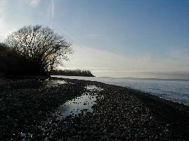
was also the glacier that made the south shore cobble beaches so much more
varied than those on the Canadian shore. When I first explored the northeastern
coast of the lake during a cruise there with Ariel in 1980 I was
immediately struck by the monotony of the beach pebbles here- they were nearly
all gray. The beaches I had grown up near in Wayne County were a colorful mix
of brown, gray, black, white, orange, and pink pebbles. We owe that variety to
the glacier which brought us vast piles of glacial till and rocks from the Adirondacks
and Canada as it advanced from the northeast. The till and these so called
glacial erratics were carried hundreds of miles, then dropped when the ice
melted. The land up near Chaumont, Henderson Harbor and the Canadian beaches
and islands on the northeast side of the lake, missed most of the erratics and
mountains of till. Here the glacier scraped the land clean and left the
limestone bedrock stripped of soil. When it melted it left no debris. The
beaches here are mostly made up of bits and pieces of their underlying bedrock
and so are uniformly gray.
The
glacier is also, of course responsible for the presence of the drumlin field
that is so characteristic of the region between Syracuse and Batavia. These drumlins are distinctively sculpted
hills of glacial till (an unsorted mixture that the glacier dragged along and
dropped made of mostly sand, clay, rocks and boulders). They are all oriented
roughly north south following the flow of the glacier and have a streamlined
elongated appearance with the north ends being steeper and the south ends
tapering gradually down. From the air they look a bit like streamlined nacelles
or perhaps like a school of swimming fish.
Between
Sodus and Oswego the drumlins meet the lakeshore and as that shoreline erodes
and eats into these hills, the distinctive clay bluffs along this stretch of
coast are created (see section on bluffs for more). This part of New
York State has one of the largest groupings of drumlins found anywhere with
over 10,000 tallied. They are a ubiquitous landform in much of Wayne County and
this little literary work was written in a house perched atop a drumlin near
the lakeshore.
While
the thought of a mass of ice a thousand feet thick lying over where my house
and word processor now exist strikes me as pretty grim, the fact is people
adapted to and even thrived during the brutal conditions of the ice age. It has
even been suggested that we may owe the beginnings of "civilization"
to ice. The theory goes that people banded together and worked cooperatively to
survive the brutal conditions of the ice age advancing language and technology
to do so. While this may be tough to prove, there is another benefit of the ice
that seems pretty clear and well documented that of its impact on soil
fertility.
As the glacier pushed its vast weight across
the land, it ground rocks into fragments and dust releasing minerals to the
soil. These minerals contribute to what the author of 1902 Geography of New
York State calls our "strong soils". Recently glaciated mineral
rich soils are far more productive than are the leached out nutrient poor soils
of the southern U.S. and the tropics. The theory goes that these northern soils
nourished crops and those who ate them with minerals that were vital to our vigor
and well being. Some historians have even gone so far as to attribute the
success of the aggressive capitalistic
northern European cultures that colonized and dominated this continent to well mineralized soils.
Many
of today's gravel and sand pits, occasional bogs and some of our big swamps
like the Montezuma marshes also owe their existence to the ice age and the
shallow glacial lakes that were formed immediately after its retreat. And today
when you hit that hard head in the north lawn with the mower, you can probably
thank the glacier for it.
From
the Edgwalker's Guide to 20 Great Beaches… watch this space for more on this
latest work from Susan Peterson Gateley